Chapter 3 – Thoreau’s Arctic Vision
On February 3, 1852, and prior to Walden‘s publication, Thoreau accurately envisioned his Concord landscape being "overwhelmed and buried" by a massive continental ice sheet creeping down from the north. His vision occurred at a time when the process of global glaciation was confused by competing paradigms: catastrophism vs. uniformitarianism. Regardless, Thoreau was fascinated by ice, snow, and climate change.

The cliffs of Aquinnah near Chilmark, Western Martha’s Vineyard, MA. The ice sheet that crept and slid over Concord followed a flow line that would have terminated somewhere near this beautiful point, which was then dry land far from the sea. The oscillating margin of that ice sheet built a moraine by thrusting up slices of much older material including from pink clay, white sand, and black mud (Thoreau’s mineral collection has some of the clay). It also smeared and dumped glacial sediment, some of which originated in Concord.
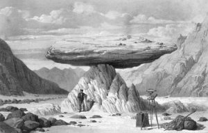
Historic etching (1843) of a rock slab held up by pillar of ice on the Mer de Glace, France. Called the "Glacier Table," it was "drawn from life" by physicist James D. Forbes, whose ideas about glaciers Thoreau cited in both his Journal and in Walden. Etching scanned from an original of Forbes’ Travels Through the Alps which is in the holdings of Harvard’s Houghton Library.

Southward view from the glacially scoured and streamlined summit of Mount Kearsarge in south-central New Hampshire. In the background, note the broad, nearly level surface called a "plateau" by Thoreau. He was right about its origin: geologists still consider it an ancestral erosion surface or "peneplane."